My name is Mike J Nagle. I have been creating political maps of the world related to the 1632/Ring of Fire series since December, 2016.
Some of the maps show the political situation at the Time of the Ring of Fire; that is, on May 25, 1631. These maps are historically accurate for the Original Timeline. Other maps show the situation at a later date in the New Timeline.
Each map is available at full-size resolution and half-size resolution.
These maps are all works in progress. While they are essentially finished, I am constantly making corrections and adding new information to them. If you last downloaded one of them more than a month ago, you may want to download it again, since it might have been changed since then.
I am still creating new maps. As each is completed, I will add it to this page.
I am sincerely grateful to 1632.org for allowing me to include my maps on their website.
| Map Thumbnail | Description |
|---|---|
| Italy at the time of the Ring of Fire.
This map is intended to support the novels in the Italian Thread. They are 1634: The Galileo Affair, 1635: The Cannon Law, 1635: The Papal Stakes, and 1636: The Vatican Sanction. |
|
 9600 x 6963 px 9600 x 6963 px4800 x 3482 px |
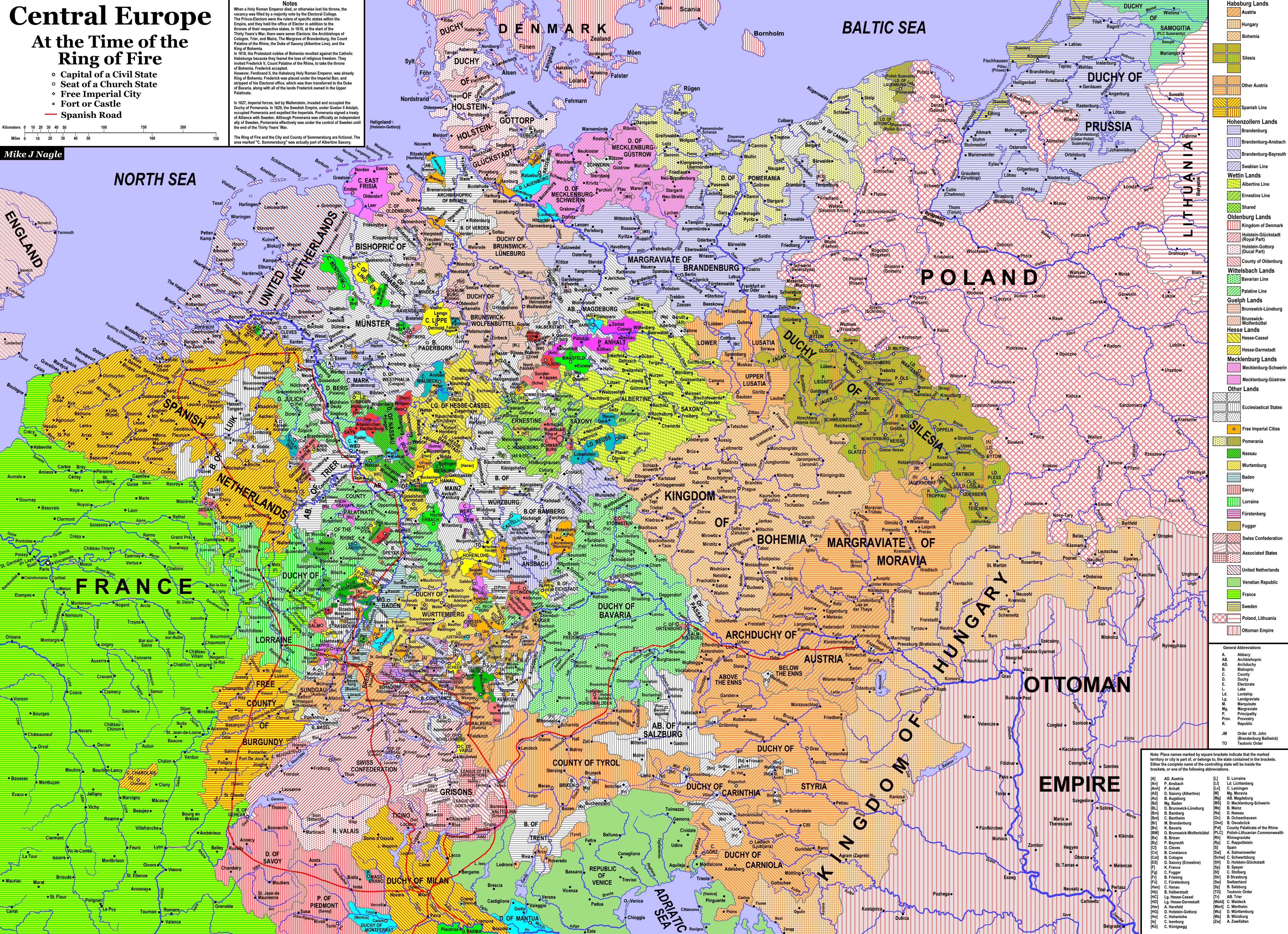
Central Europe at the Time of the RoF
This is a general-reference map covering the Holy Roman Empire. It is historically accurate, except that it also shows the Ring of Fire and the County of Sommersburg, both of which, of course, are fictional. |
 4544 x 3860 px 4544 x 3860 px2272 x 1930 px |
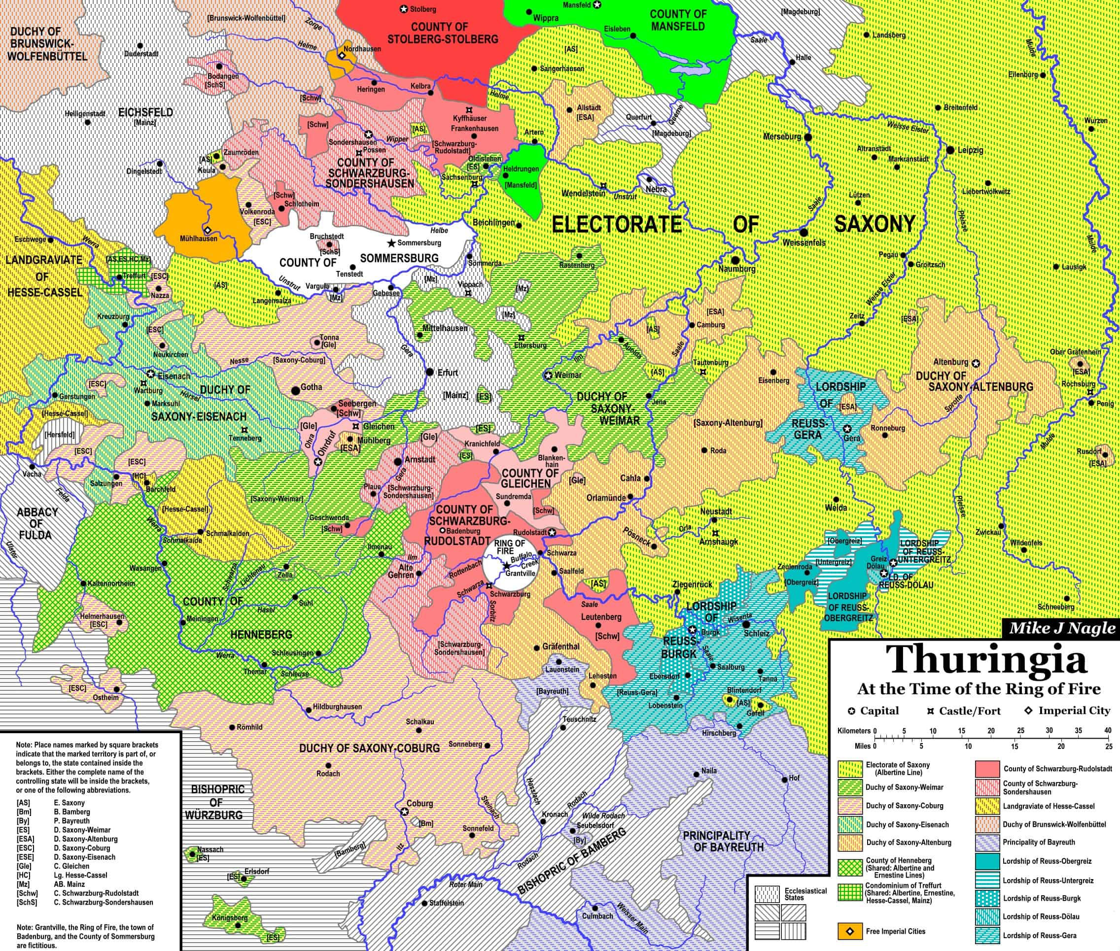
Thuringia at the Time of the RoF
This map shows Thuringia, the part of Germany where Grantville ended up, in greater detail. It shows Grantville, the Ring of Fire, Badenburg, and the County of Sommersburg, all fictional places. Aside from that, it is historically accurate. |
 7500 x 9460 px 7500 x 9460 px3750 x 4730 px |
South America at the Time of the RoF
A general-reference map showing the extent of Spanish and Portuguese colonization at the time of the RoF. This map also shows the West Indies at the time of the RoF. |
 6000 x 7922 px 6000 x 7922 px3000 x 3961 px |
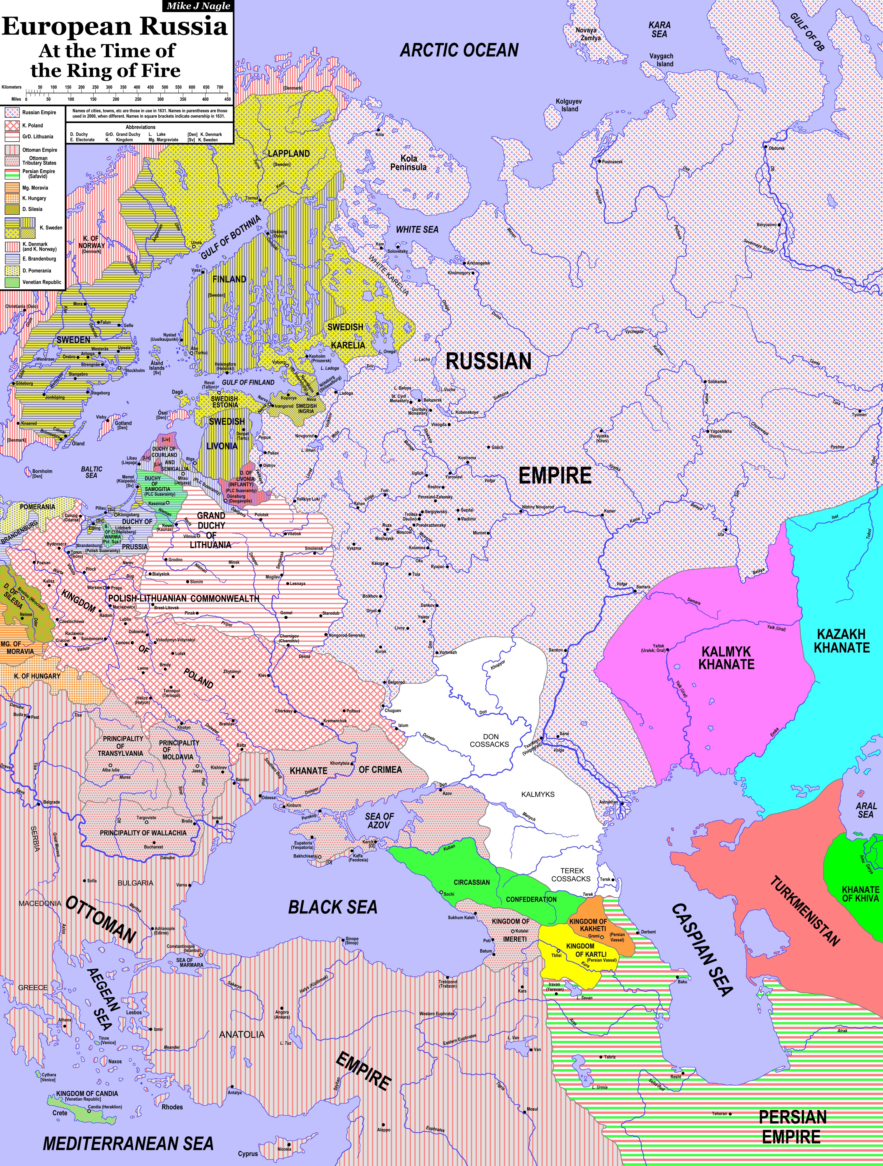
European Russia at the Time of the RoF
This map is intended to support 1636: The Kremlin Games and 1637: The Volga Rules. |
 7000 x 8350 px 7000 x 8350 px3500 x 4175 px |
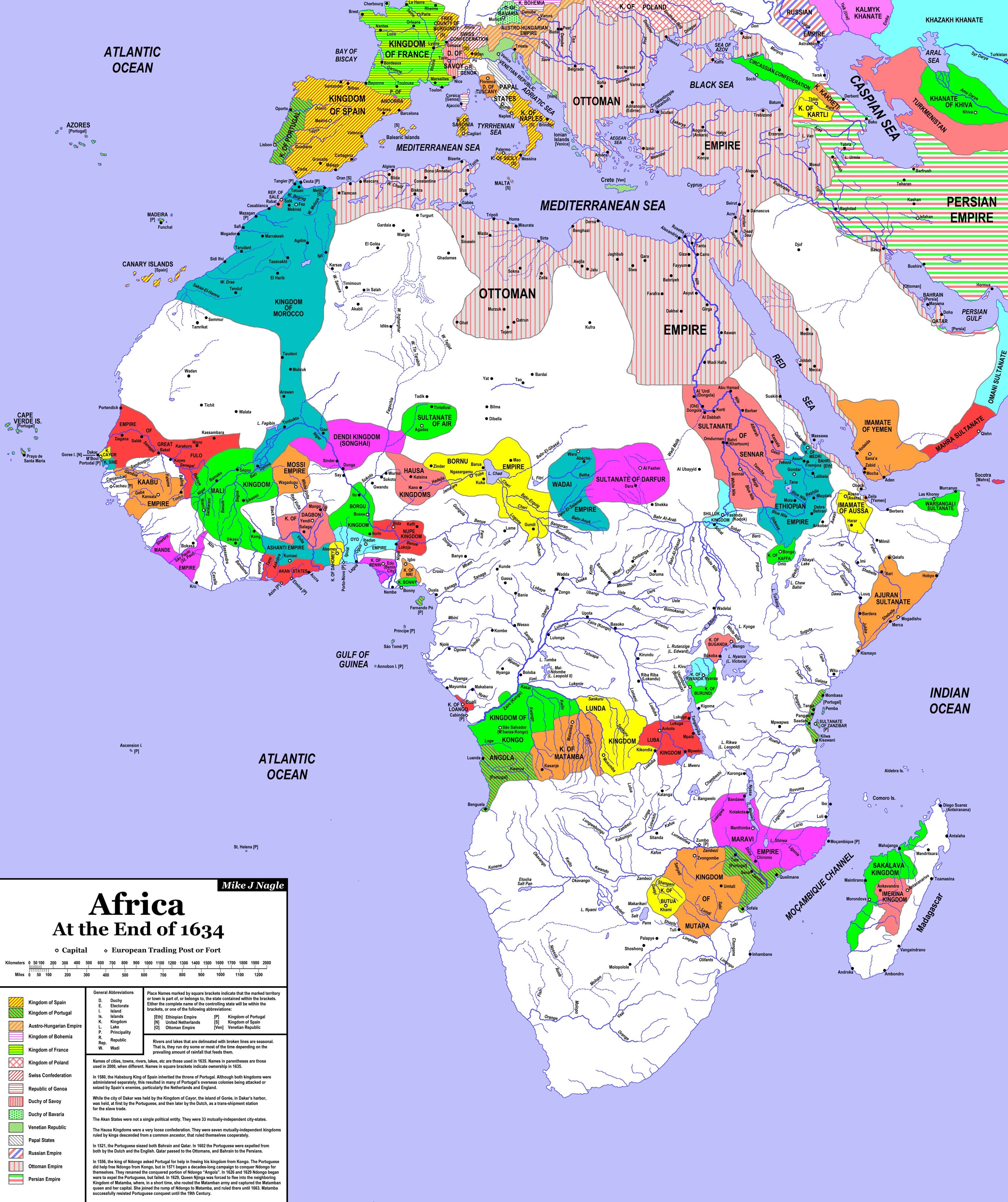
Africa at the End of 1634
A general-reference map showing the various indigenous nations of Africa and the extent of European colonization at the end of 1634. |
 7500 x 8679 px 7500 x 8679 px3750 x 7340 px |
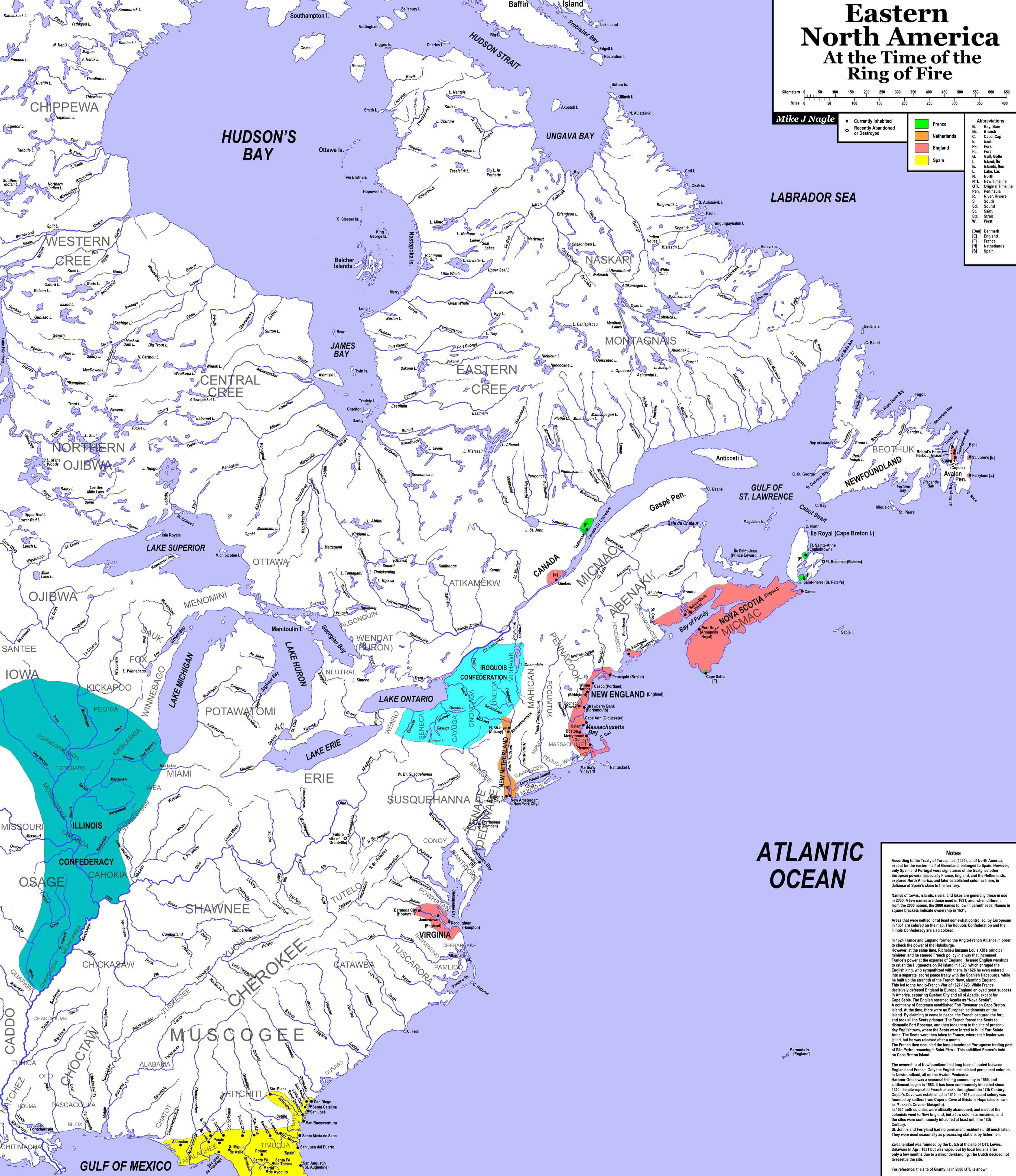
Eastern North America at the Time of the RoF
The European colonies on the Atlantic coast of North America at the time of the Ring of Fire. |
 7500 x 8679 px 7500 x 8679 px3750 x 7340 px |
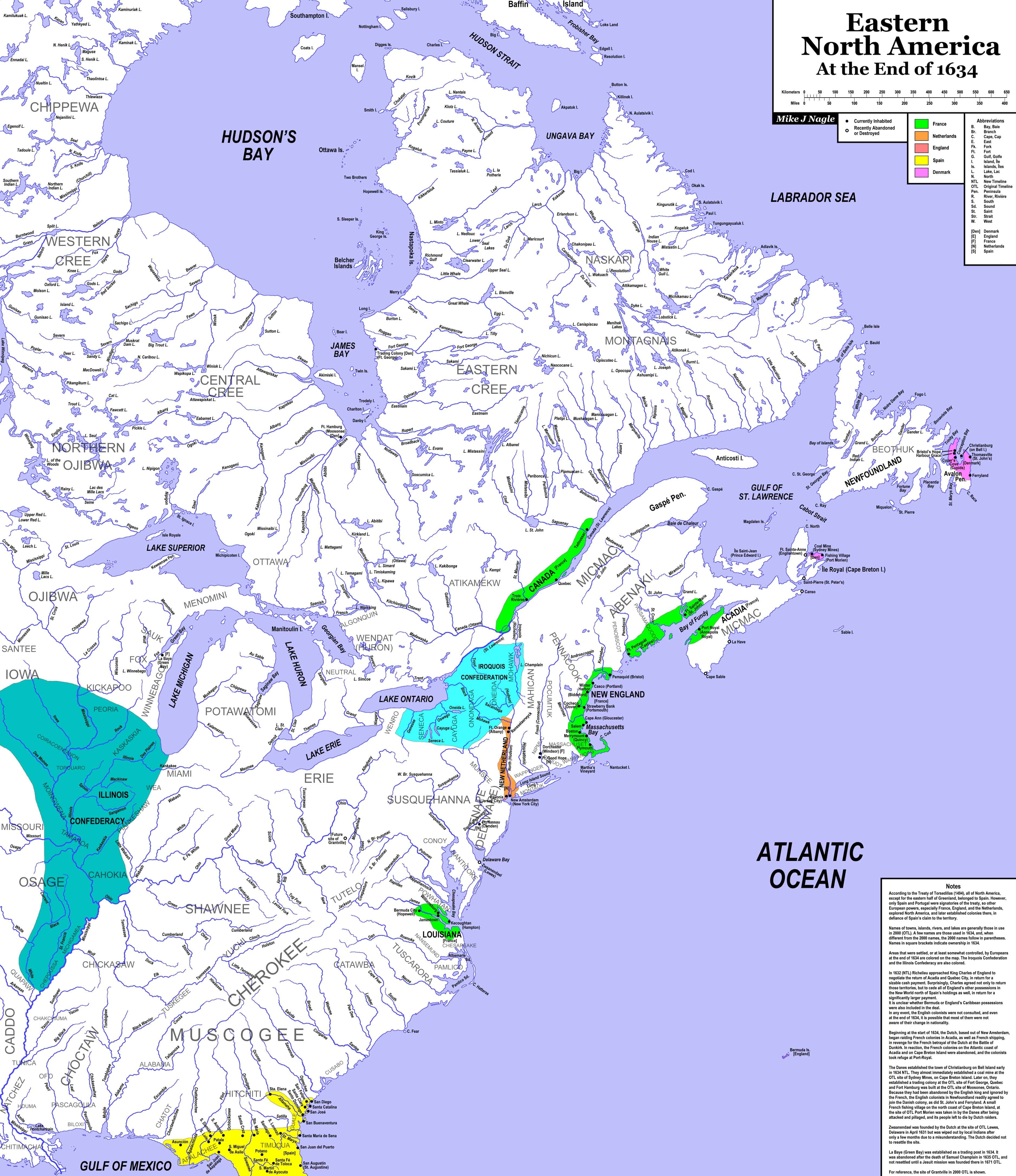
Eastern North America at the End of 1634
The European colonies on the Atlantic coast of North America at the end of 1634, after the secret treaty between France and England that transferred all of the English possessions to France for a substantial cash payment. This map to is intended to support The Danish Scheme, 1635—The Battle for Newfoundland and the forthcoming 1636: The Atlantic Encounter. |
 9300 x 7697 px 9300 x 7697 px4550 x 3849 px |
Mexico and Central America at the end of 1634
The situation in New Spain at the end of 1634. |
 7500 x 6221 px 7500 x 6221 px3750 x 3111 px |
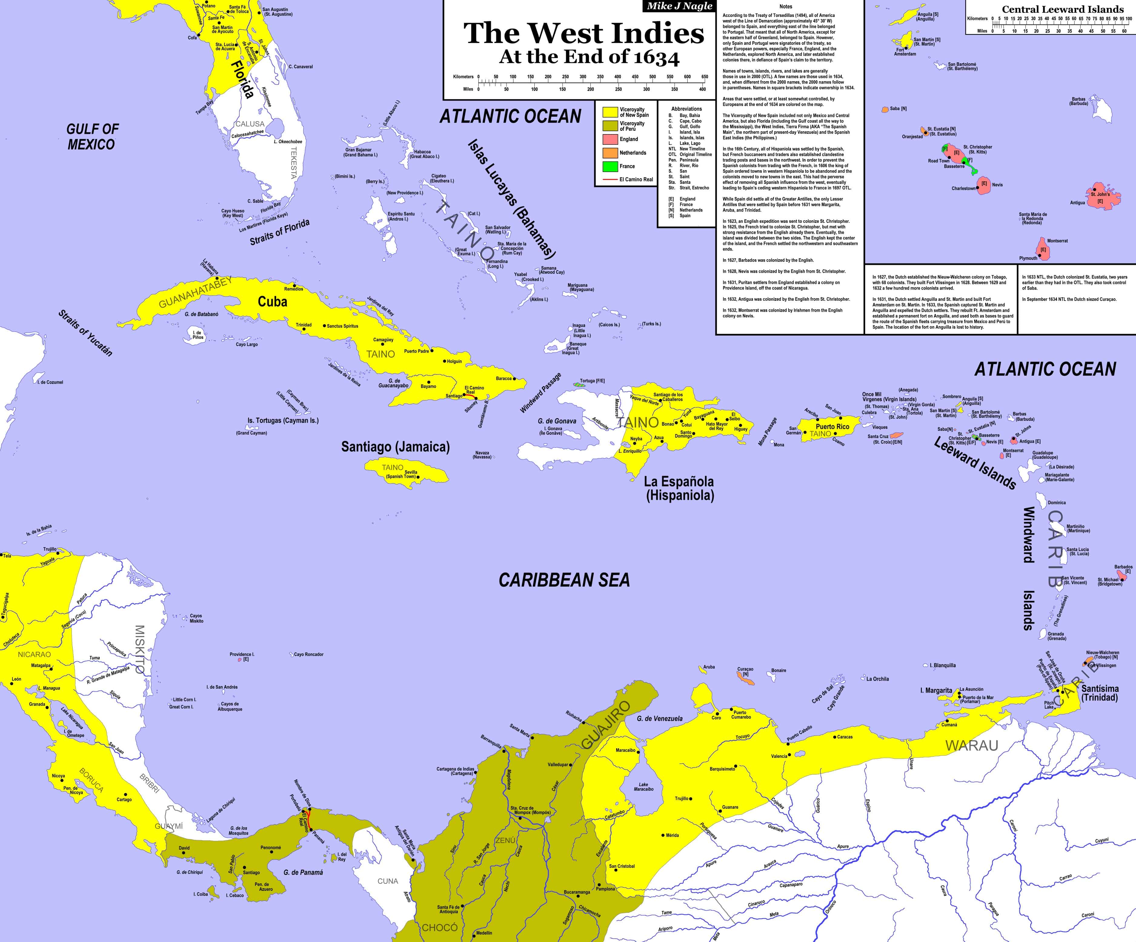
West Indies at the end of 1634
The situation in the West Indies at the end of 1634. The West Indies at the Time of the Ring of Fire can be seen on the South America map, although at a much smaller scale. This map includes about a dozen towns and several rivers in the West Indies and South America that were not included on the South America map. |
 9000 x 8500 px 9000 x 8500 px4500 x 4250 px |
India at the End of 1634
The situation in India at the end of 1634. This map is intended to support 1636: Mission to the Mughals. |
 8000 x 6604 px 8000 x 6604 px4000 x 3302 px |
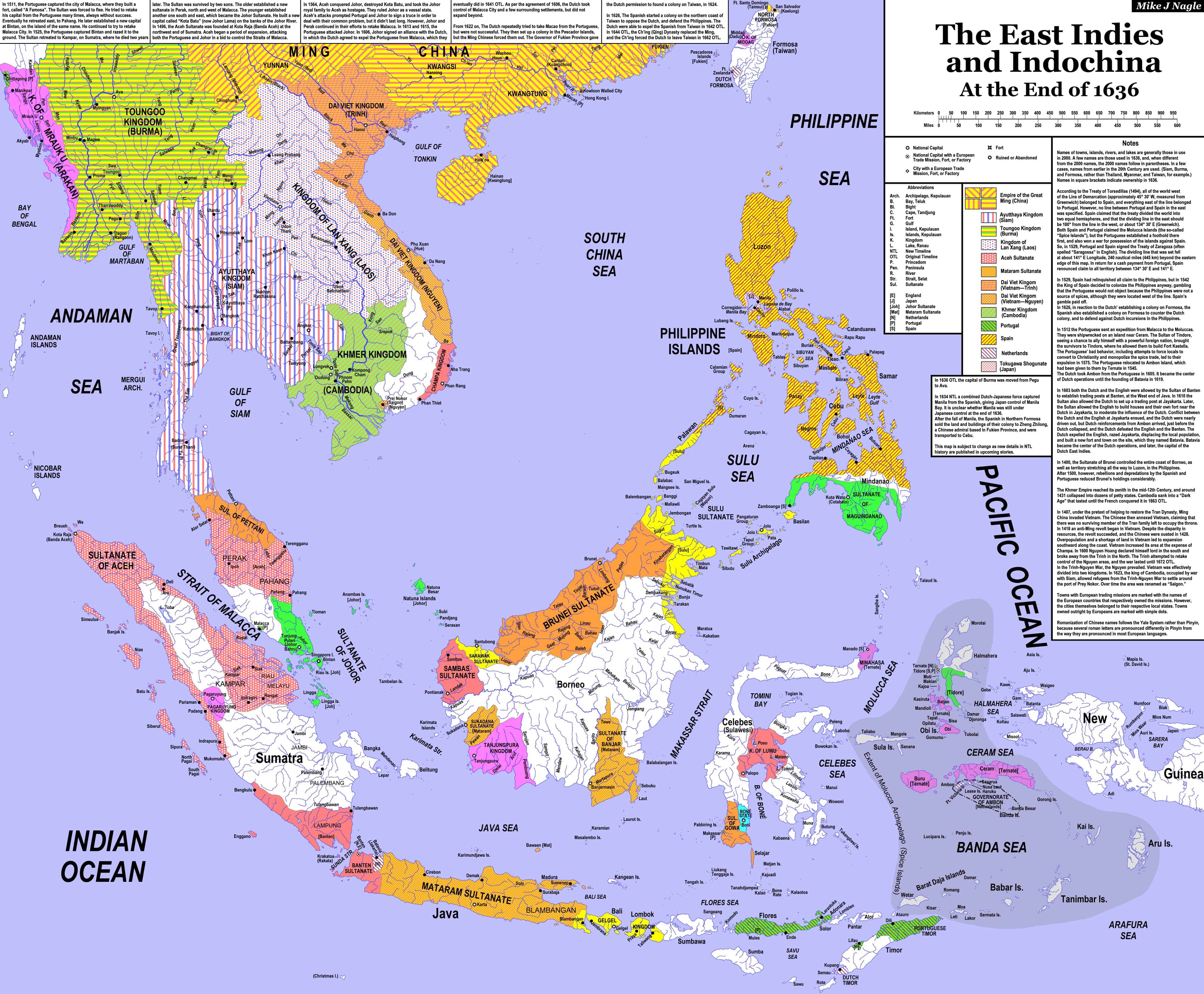
The East Indies and Indochina at the end of 1636
The situation in the East Indies at the end of 1636. A general-reference map of Southeast Asia at the end of 1636. 1636: The China Venture is currently in the works. Sometime in the hopefully-not-too-distant future, it should be published. When it is, the situation in southern China, Formosa (Taiwan), and the Philippines will certainly need to be revised to reflect the NTL changes that will be introduced by the novel. Meanwhile, Formosa and the Philippines are not accurate for the end of 1635 (NTL). They are only accurate up to the end of 1635. |
 8000 x 5643 px 8000 x 5643 px4000 x 2822 px |
Japan and Korea at the end of 1635
The situation in Japan and Korea at the end of 1635. |
 9600 x 6963 px 9600 x 6963 px4800 x 3482 px |
Central Europe at the End of 1636
This is a general-reference map covering Central Europe at the end of 1636. This map shows all of the changes in Central Europe after the Ring of Fire Event. |

I keep getting this message whenever I try to access one of the maps:
“Forbidden
You don’t have permission to access this resource.Server unable to read htaccess file, denying access to be safe”
What on Earth is going on here?
Great work, I love it!
Since you said that you continue to tinker with the maps, I will point out a minor thing for “European Russia at the Time of the RoF” map:
Principality of Wallachia, by ROF time, already lost a few towns north of Danube – Braila (that appears in the map), Giurgiu (just south of Bucharest) and Turnu (a little west of Giurgiu).
https://en.wikipedia.org/wiki/Wallachia
“Radu Paisie, who was deposed by Süleyman in 1545, ceded the port of Brăila to Ottoman administration in the same year.”
“Mircea the Elder […] accepted a peace treaty with the Ottomans in 1417, after Mehmed I took control of Turnu Măgurele and Giurgiu.[30] The two ports remained part of the Ottoman state, with brief interruptions, until 1829.”